Civic Insights: Who Pays for that Pipe? Part III
(City council, school board, planning commission, county commissioners – these groups and several others represent us. They do the day to day work of running our community. It is our responsibility to keep informed about their work so that we can help them represent us effectively. “Civic Insights” by Jeffrey Vitarius is a regular feature of Act Locally Waco. Its purpose is to help us understand decisions that shape our community so that we can participate effectively as informed, engaged residents of Waco. – ALW)

By Jeffrey Vitarius
Back in September, we began this series with a broad look at what an impact fee policy is. Two weeks ago, we focused on the legal process for establishing an impact fee. This week we will be taking a look at pipe-related details of the report that serves as the basis for any impact fee policy in Waco. Next week, we’ll take a look at the roadside of things. Then we will wrap up on the 23rd, by looking at the policy the City will be considering on the 20th.
The goal of this report (developed by Freese and Nichols, Inc) is to calculate the maximum impact fees that could be applied under Chapter 395 of the local government code. As we discussed two weeks ago this involves projecting what kind of development will occur, what the demands of that development will be, what projects will be needed to meet that demand, and how the cost of those projects can be divided up amongst the new developments (steps 2 and 4 of the legal process). How these calculations are conducted for pipes and roads are slightly different so we will take a look at each separately, but both follow a similar pattern of calculations. We will be addressing each step in detail below:
- Determine a service area
- Identify a way to connect demand for service to supply for service
- Calculate increased demand for services
- Review existing supply for services
- Determine and cost projects needed to meet increased demand
- Identify service unit to divide costs amongst projects
- Calculate maximum impact fees
Let’s start with the Pipes:
1. Service Area
Service areas are the geographic boundaries of the impact fee policy. All the new demand, all the projects, and all the fees should be contained within the service areas. Chapter 395 provides guidance on what these areas can be or must be. For pipes, the service area is fairly straightforward. It includes the city limits of Waco along with Waco’s extraterritorial jurisdiction (ETJ). An ETJ can be thought of as a “buffer” around the city where the city can exercise certain kinds of authority. For Waco, the ETJ extends approximately five miles beyond the city limits unless there is another city in the way. For example, Woodway is not in the City of Waco’s ETJ since it is its own city.
2. Connecting Demand and Supply
Here we need to find some measurement to connect a new house or business park (demand) to the existing system and potential projects (supply). The measurement needs to be scalable to the variety of demands that will come from new development and be measurable for distinct projects and supply systems. For pipes that measure is millions of gallons per day (MGD). So, for a new housing development, MGD measures the millions of gallons of water needed each day and the millions of gallons of wastewater produced each day.
Water systems have a unique difficulty in that they are not used consistently over days and years. This makes sense if you think through your personal use of the water system. In hot dry summers you are more likely to be watering a lawn than in cold or wet winters. You are unlikely to be using the water system at 1:00 am, but you are likely to be washing your clothes, or taking a shower, or washing your hands sometime in the early morning or afternoon (for those interested these daily patterns are also called “diurnal patterns”).
Due to these daily and annual changes, looking at average MGD does not give a full picture of the demands placed on the water system. Instead we have to look at maximum MGD as well. That is the maximum number of millions of gallons used on any one day during the year. Interestingly, the report uses a “maximum day to average day” ratio of 1.7 meaning it anticipates that on average a maximum day consumes 1.7 times as much water as an average day.
Finally, to calculate increased demand over time the report calculates average MGD per resident and employee (for water its 135 gallons per day per resident and 115 gallons per day per employee). There are some additional complications to the wastewater system, but the process is largely the same.
3. Increased Demand
Above we were able to tie increased demand for pipes to increases in population and employment. Now we need to figure out what that increase actually is and how it is geographically spread out (this impacts the specific projects that will need to be undertaken).
As we touched briefly on two weeks ago, we have to start with a broad look at how much Waco will grow in terms of population and employment into the future. To do that, the study begins with a look at the past. Between 1960 and 2010 Waco’s population grew on average 0.49% per year (the technical metric for those interested is compound annual growth rate). Between 2010 and 2020 the population grew by 1.11% per year. Additionally, the number of jobs in Waco was on average between 45-48% of the total population. So, for about every two people there was about one job. Due to this ratio being fairly constant, jobs can be considered to have grown at approximately the same rate as population.
Freese and Nichols then (in consultation with the Waco Capital Improvements Advisory Committee) took a look at a number of different growth rate scenarios and ultimately determined that 1.2% seemed like the most reasonable projection of population and employment growth in Waco for 2020-2040. Additionally, they noted growth was likely to be substantially greater in the ETJ (as there is more room for development in this area). For the ETJ they projected between 4.9% and 5% population growth and 4.06% and 5.74% employment growth. Now that we have general growth rate numbers, we need to understand how that growth is spread out geographically.
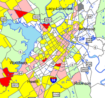
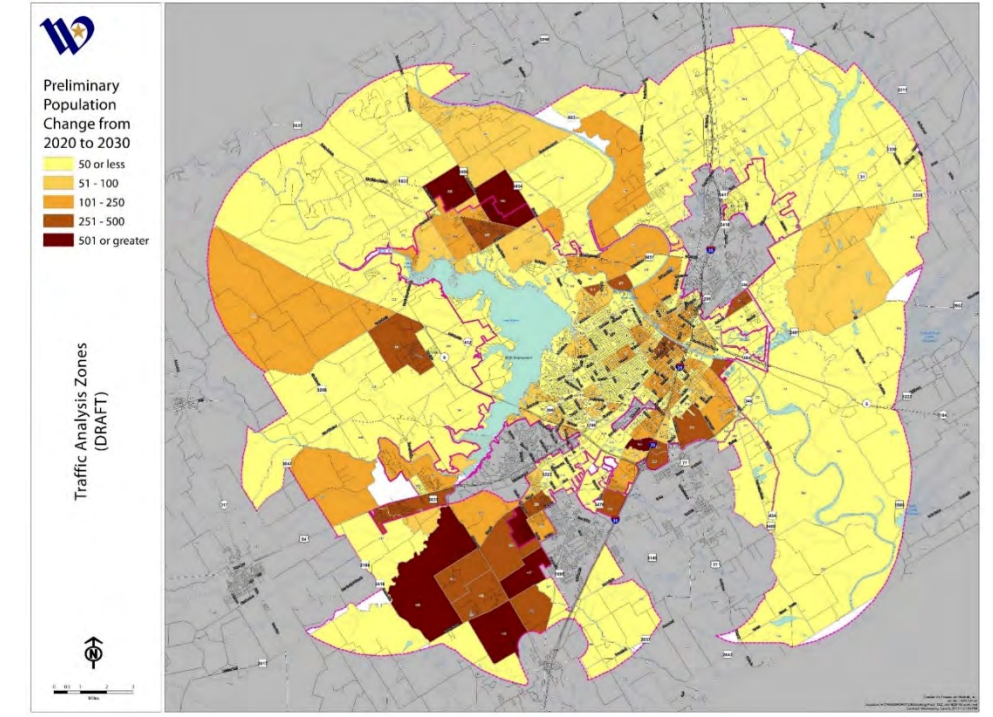
To divide growth geographically, the report uses “traffic analysis zones” (TAZs). These are geographic units used by the Waco Metropolitan Planning Organization (a good topic for a different time) for demographic analysis due to their internal similarity (areas within TAZs are similar to each other) and traffic generation. Here is a map of some of the TAZs within Waco. This map does not come from the impact fee study,but should give some understanding to what TAZs are.

Freese and Nichols along with City Staff analyzed each TAZ. They looked at current development (what is already there), the potential for development (is there a big open field?), projected land use, and any specific projects that were known to be in the pipeline. Based on this analysis they were able to project growth in employment and population within specific TAZs. Here is an example of the result:

A quick side note, the land use assumptions used in this analysis come from Waco’s Comprehensive Plan 2040. This was the same plan that identified the impact fee policy as critical.
Now we know: a) expected new residents and employees in each TAZ and b) expected new pipe usage based on new residents and employees. Combining the two we know how much water/wastewater will be needed and where it will be needed.
4. Existing Supply & 5. New Projects
Now that demand is known geographically, Freese and Nichols along with City Staff were able to identify where the existing system would need to be upgraded to meet with the projected demand (this process involved a review of other recent studies focused on the subject). The result is a list of twenty-three water projects and seventeen wastewater projects. Here are some examples: a 16-inch water line at Peach Street, a 1.0 MG ground storage tank at the airport, a wastewater treatment plant in China Spring, and a lift station expansion at TSTC. Costs for each of these projects were calculated based on the rules established by Chapter 395 (which is fairly specific about what kinds of costs may or may not be included).
Since impact fees cannot be used to support existing development or development that will take place over 10-years from now, the report takes each of these projects and determines what percentage of the project’s capacity would be used right now, and what percentage would be used in 2030. For example, the 16-inch water line at Peach Street would be used at 25% capacity today and 60% capacity in 2030. That means 35% of the project cost can be considered to be the cost of new development between 2020 and 2030.
Combining all the allowable costs together, the report then applies a 50% credit to the costs. This credit is meant to represent the future tax revenues that will come from the increase in development. Essentially it represents how the new development will “pay” for these improvements through the regular tax process rather than the impact fee.
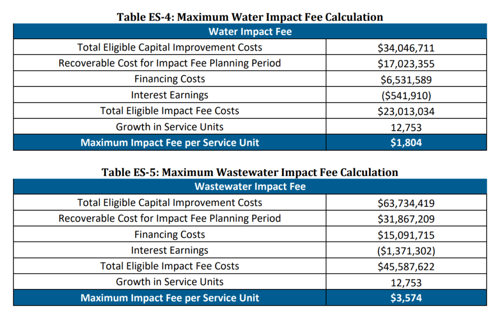
At the end of this process we have the total eligible impact fee cost – the total cost of increased capacity due to new demand after consideration of a credit for future taxes (water – $23,013,034, wastewater – $45,587,622). But how do we divide those costs up so that individual developments pay for them as they come into existence?
6. Service Unit
Chapter 395 calls for the establishment of a “service unit.” It defines “service unit” (in broad terms) as a standardized measure of consumption. Since it would be virtually impossible to determine the exact number of residents or employees a development would have, we cannot use the same metric we used to connect demand and supply (MGD per resident and MGD per employee).
Ultimately, for this study the connection of a single-family residence was used as the base service unit. The study then measures all other kinds of water and wastewater connections on the scale of single-family residence equivalents (on the basis of average flow). For an example a business park connection might be considered equivalent to ten single-family residences since ten times the amount of water flows through it (this is not a number used in the study, but rather a nice round one for an example).
7. Maximum Impact Fee
Knowing our service unit and our total eligible costs, the final step can be taken. A projection is made of the total new service units anticipated by development (in much the way step 3 proceeded). In the case of water and wastewater that number is 12,753. That is, the study anticipates that 12,753 “single-family resident connection equivalents” will be added to the water and wastewater system over the next ten years. With that number in hand, it is a simple matter of division to determine the maximum impact fee. The chart below completes the process.

Here we see that after all these steps the maximum impact fee allowable by law for water is $1,804 and for wastewater is $3,574. These numbers are the final product of that could process we discussed at the very beginning of all of this. Whatever the outcome of the should process is, the impact fees cannot exceed these amounts for a single-family residence connection equivalent.

Jeffrey Vitarius has been actively local since early 2017. He lives in Sanger Heights with partner (JD) and his son (Callahan). He helped found Waco Pride Network and now serves as that organization’s treasurer and Pride Planning Chair. Jeffrey works at City Center Waco where he helps keep Downtown Waco clean, safe, and vibrant. He is a member of St. Alban’s Episcopal Church and graduated from Baylor in 2011.
The Act Locally Waco blog publishes posts with a connection to these aspirations for Waco. If you are interested in writing for the Act Locally Waco Blog, please email [email protected]for more information.
